Data News: "Bawei" or the strongest typhoon landing in Northeast China in history?
China Meteorological News reporter Su Jessie Wang Meili
Expert Consultant: Zhou Guanbo, Senior Engineer of Central Meteorological Observatory
This year’s No.8 typhoon "Bawei" was generated in the sea east of Taiwan Province at 8: 00 on August 22nd, and then it will land in the coastal areas from eastern Liaoning to western Korea on the morning of August 27th (typhoon level, 12-13, 33-38m/s). If it lands in Liaoning, "Bawei" may become the strongest typhoon that landed in Liaoning since 1949.
Is it rare for a typhoon to land in Northeast China? What are the characteristics? Let’s find out from the typhoon big data since 1949.
There has been no typhoon landing in Northeast China in recent 15 years.
Among the typhoons (including tropical depression) that landed in China from 1949 to 2020, 13 landed in Northeast China, but no typhoon landed in Northeast China in the past 15 years since 2005.
Of the 13 typhoons that landed in Northeast China, all landed in Liaoning. This is because only Liaoning has a coastline, and its geographical location directly determines that it is the most windy province among the three northeastern provinces.
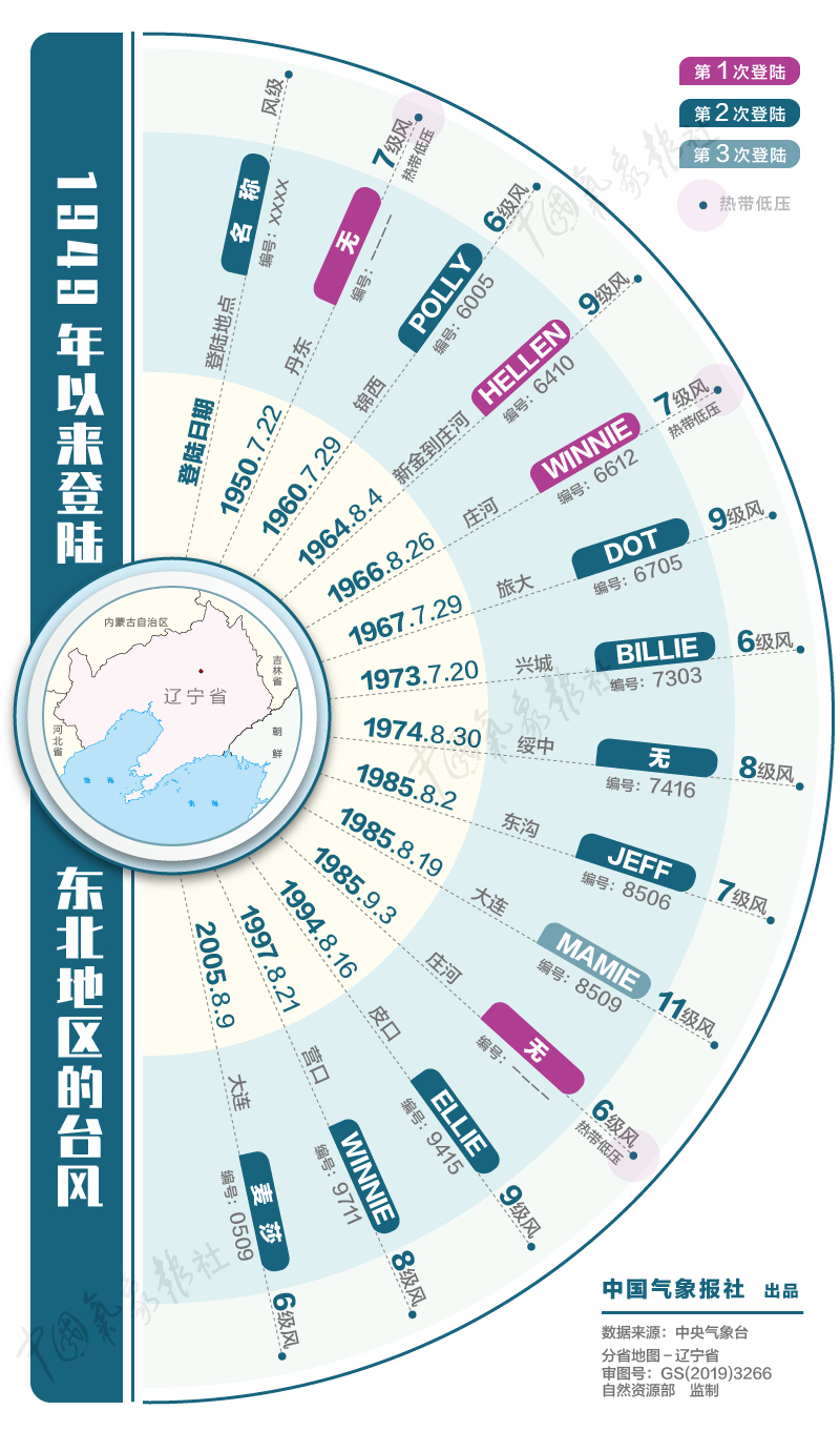
A typhoon that has landed in the northeast since 1949. Zhao Miao cartography
Typhoons in the north are not uncommon, and most of them are "second-hand"
In the 70 years since 1949, only one typhoon "Helen" landed in Northeast China with the intensity above tropical storm, and the other three landed in the form of tropical depression. "Helen" landed in zhuanghe city, Dalian, Liaoning Province on August 4, 1964. The maximum wind force in the center was 9, and the wind speed reached 23 meters per second.
Because the typhoons going northward are mostly "second-hand" or "third-hand", in terms of intensity, they have basically exhausted their energy when they go northward, so the intensity of landing is generally at the tropical storm level, and some can reach the strong tropical storm level.
Judging from the landing time, typhoons heading north are mostly concentrated in late July and August. This is mainly because the subtropical high is located in the south from June to July, and the typhoon path generated at this time is mostly westward; In August, the subtropical high moved northward, which was beneficial for the typhoon to move northward along the west side of the subtropical high after its formation, thus affecting the northeast region; After September, the subtropical high began to retreat to the south, and the probability of typhoon going north would be much reduced.
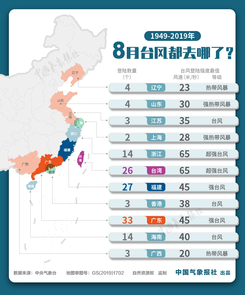
Where did the typhoons go in August?Zhao Miao cartography
A typhoon that does not land in the northeast can also "beat cattle" across the mountain.
In addition to the typhoons that landed in Northeast China, there are also some typhoons that have brought great wind and rain impacts to Northeast China.
In 2012, Typhoon No.15 "Blavin" moved mainly in the northwest in the early stage, and then moved mainly in the north direction after entering the northern part of the East China Sea. After landing in Korea, it entered Jilin and Heilongjiang in China on August 29th. On the way to the north, it was combined with cold air. From August 27 to 29, the rainfall in central Heilongjiang, central Jilin, central and eastern Liaoning and eastern Shandong Peninsula was 100 to 150 mm. Strong winds of magnitude 7 ~ 9 have also appeared in inland areas such as central and eastern Liaoning, central Jilin and central and eastern Heilongjiang.
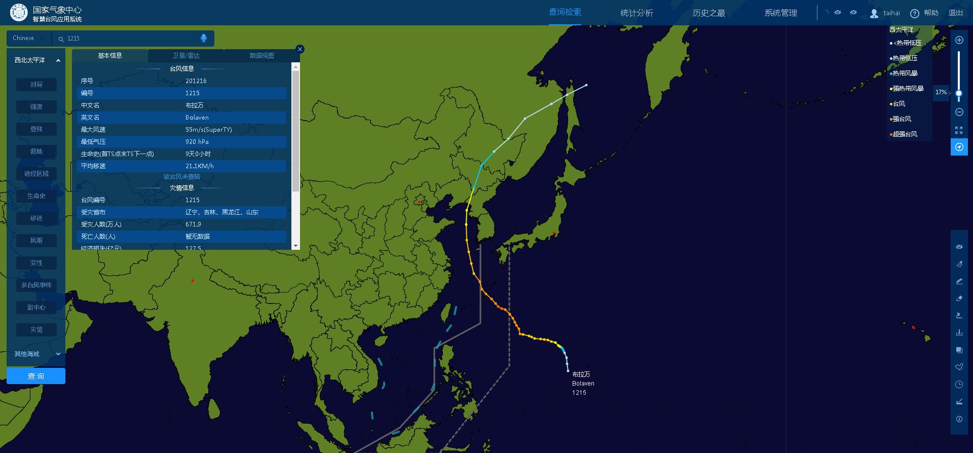
Track Map of Typhoon Blavin No.15 in 2012
On the afternoon of September 7, 2019, after the No.13 typhoon "Lingling" landed in North Korea as a typhoon, it moved into Jilin at 2100 hours as a tropical storm, and then quickly moved north. From September 6th to 8th, due to the influence of Lingling, heavy rain and local heavy rain occurred in the central and eastern parts of Northeast China. The local area of Lanxi, Heilongjiang Province was 233 mm, and the daily rainfall of 26 stations in Heilongjiang, Jilin and Liaoning exceeded the historical extreme in September since the establishment of the station. There are 7 ~ 9 gusts in Shandong Peninsula, northern Liaoning and Liaodong Peninsula, central and eastern Jilin and central and eastern Heilongjiang, and 10 ~ 13 gusts in northeastern Jilin and southeastern Heilongjiang.
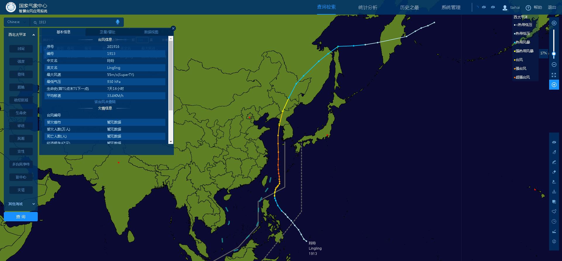
Route Map of Typhoon Lingling No.13 in 2019
In addition, Typhoon Winnie No.11 in 1997, Typhoon Lion Mountain No.10 in 2016 and Typhoon Wambia No.18 in 2018 also brought great influence to Northeast China.
Typhoon heading north is easy to combine with cold air to cause heavy precipitation.
Typhoon northward has obvious characteristics:
First of all, as the typhoon moves northward, it may combine with cold air on the way northward, and the intersection of cold and warm air will cause heavy precipitation.
Secondly, the northbound typhoon may go through a process of "degeneration". The "denaturation" mentioned here refers to changing the nature, and some northbound typhoons will change from tropical cyclones to temperate cyclones. During the northward movement of typhoon, it was influenced by cold air and the decrease of sea surface water temperature, and its central temperature field was no longer a warm core structure, and its low-pressure center changed from vertical to inclined with the height change, so its nature has changed, and the warm and humid air brought by tropical cyclone itself changed into precipitation produced by combining with cold air.
Thirdly, due to the long coastline in the east of China, the path of some typhoons going northward is along the offshore of China, which may have an impact on the eastern coastal areas of China. Compared with typhoons landing in South China, more provinces will be affected.
Because there is relatively little experience in typhoon prevention in the northern region, the public should take safety defense measures, pay attention to forecast and early warning information in time, and be prepared for strong winds and heavy rainfall. Coastal areas should pay attention to the impact of storm surge. Liaoning and other places are alert to the occurrence of secondary disasters, and the meteorological risk of floods in small and medium-sized rivers in the lower reaches of Liaohe River and Yalu River tributaries is high. In addition, strong winds may also cause crops to lodging and damage agricultural greenhouses, which will have a certain impact on agriculture and need to be prevented in advance.
(Editor: Su Yujun)